Dear visitors! Welcome to my official website, currently it is still in progress so
I apologize for any mistakes which you may find :(
Hello visitors! whichever the reason which brought you here, I hope that you can find here something interesting for you,
something what may help you or something that you may like ;)
Here is brief introduction about my study and experiences:
PRACTICE
1.11.2017 – present Data analyst for Slovenská sporiteľňa (member of ERSTE group) - Retail reporting department
1.3.2016 – 31.10.2017 Data analyst for VÚB bank (member of Intesa Sanpaolo group) - Data office department - master data management section
2013 – 2016 University assistant at University Comenius, faculty of Natural Sciences, department of cartography, geoinformatics and remote sensing, and researcher at University Scientific Park of Comenius University in Bratislava
2008 – 2012 Freitag & Berndt s.r.o.
STUDY
2011 – 2017 PhD degree: Comenius University in Bratislava, faculty of Natural Sciences, department of cartography, geoinformatics and remote sensing. (specialization on spatial information infrastructure and environmental health)
2009 – 2011 Master degree: Comenius University in Bratislava, faculty of Natural Sciences, department of cartography, geoinformatics and remote sensing. (specialization on geographical information systems - GIS)
2006 – 2009 Bachelor degree: Comenius University in Bratislava, faculty of Natural Sciences, department of cartography, geoinformatics and remote sensing. (specialization on geography and cartography)
Example of the web map application which is displaying the spatial deployment of ATM machines in Bratislava including additional spatial layers
On this example it is possible to see how easy it is to display our own data on the Openstreetmap map layers.
All displayed data is real which is displaying ATM machines of the most significant banks in Bratislava city.
other data available here are highlighting important buildings in Bratislava plus population density in 2011.
To display full screen map click here.
Embedding external web map application
Adding external web map application on website could be easier than you expected!
Some applications allow us to embed and share content directly through the "tag" which can be easily added into the website source code:
<iframe> eg. windy.com
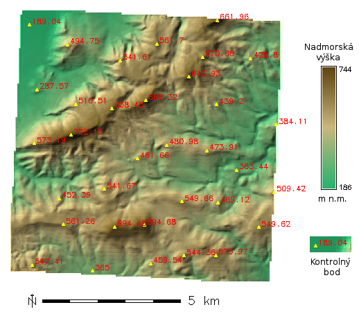
Quality assessment of digital elevation model
Comprehensive design methodology for quality evaluation of digital elevation models including information of available technical
standards that deals with evaluation of the quality of geographic data you can find in my master theses in
publications section.
Geographical analysis and applications
Nowadays exists really advanced GIS technologies which allow us to work with spatial data at advanced level
(and now I am not talking only about commercial technologies but opensource like GRASS GIS, QGIS, ...)
One of the ways how to automate processes like running programs of the GRASS GIS technology according to the way how we want,
could be done through operation system Linux and the very powerful shell program.